The Ojai Basin
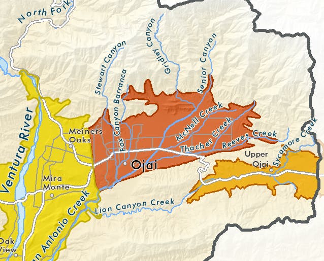
Location: The Ojai Basin is located in the Ventura River watershed in Ventura County. The basin, shown in rust on the adjacent map, lies under the City of Ojai and the Ojai Valley’s East End. Its surface area is 6,471 acres (10.1 sq. mi.).
Uses: The basin serves a large number of people and agricultural acres. Approximately 149 wells in the basin supply water to tree crops (mostly citrus and avocados), residents, and businesses in the City of Ojai and surrounding areas. Some water from the basin is also naturally discharged to San Antonio Creek, supplying native habitats and the animals they support, as well as downstream water users.
Geology/Hydrology: The Ojai Basin a relatively deep, bowl-shaped basin, which is bounded on the west and east by non-water-bearing Tertiary aged rocks, on the south by the Santa Ana Fault and Black Mountain, and on the north by the Topatopa Mountains.
Major surface drainages that contribute influx or recharge to the basin include San Antonio Creek and the various tributary streams that drain the East End of the Ojai Valley and flow into San Antonio Creek. Steep slopes in these creeks—especially those flowing out of Senior Canyon and Horn Canyon/Thacher Creek—are responsible for forming extensive alluvial fan deposits as the fast-moving, debris-laden water coming out of the mountains slows, spreads out, and deposits suspended sediment. These deposits of sand and gravel, thick¬est closest to the mountains in the northeastern portion of the basin, are largely responsible for filling the Ojai Basin over time and forming the water-bearing aquifers of the basin.
The basin is deepest in the center and southern areas where sediments have built up against the boundary defined by the Santa Ana Fault. The maximum known thickness of the alluvium is 900 feet.
The Ojai Basin has areas of confined, semi-confined, and unconfined groundwater. Unconfined conditions exist in the northern and eastern portions of the basin, in the areas of the alluvial fan heads. Groundwater in the rest of the aquifer system is, depending on the amount of water in storage and groundwater level position, mostly confined to semi-confined in the central, southern, and western portions of the basin.
Groundwater generally flows in a southwesterly direction; however, it also flows towards the municipal wells in the central portion of the basin. During wet periods, artesian conditions or springs can occur in the southwestern part of Ojai Basin when the elevation to which groundwater will naturally rise exceeds the ground surface elevation.
Capacity: The Ojai Basin has the largest capacity of the Ventura River watershed’s four groundwater basins. It has a maximum capacity of approximately 85,000 acre-feet, with a safe annual year of approximately 5,026 acre-feet. (Note: A groundwater basin’s maximum capacity does reflect the amount of available water. Much of that water is not usable or economically recoverable.)
This basin is quickly recharged during wet periods, and can be rapidly depleted during periods of drought. For example, in just seven months, between March 2012 and October 2012, water levels in the Ojai Basin dropped 84 feet. On the other extreme, in 1952, the heavy winter rainfall was sufficient to return the groundwater in the Ojai Basin to near maximum levels, even though the basin was at historic low levels following five years of deficient rainfall. In terms of the long-term average, however, amount of groundwater in storage has been fairly stable.
California’s Groundwater: Bulletin 118Hydrogeology of the Ojai Groundwater Basin - Kear 2005
Sources:
- California Department of Water Resources. 2003. Bulletin 118: California’s Groundwater
- Daniel B. Stephens & Associates, Inc. 2011. Groundwater Model Development – Ojai Basin, Ventura County, California.
- Kear, J. 2005. Master’s Thesis. Hydrogeology of the Ojai Groundwater Basin: Storativity and Confinement, Ventura County, California.
- Ventura County Flood Control District. 1971. Ventura County Water Resources Management Study, Geohydrology of the Ventura River System: Ground Water Hydrology.
- Ventura County Watershed Protection District. 2009. Alluvial Fan Floodplain Mapping: East Ojai FLO-2D Floodplain Study
- Walter, L. 2015. Ventura River Watershed Management Plan